-40%
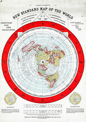
Flat Earth Map LARGE 23"x32" Alexander Gleason 1892 Standard Map of the World
$ 9.47
- Description
- Size Guide
Description
Alexander Gleason's New Standard Map of the World Flat EarthDetailed Specifications
This is a reproduction of the original map.
Size: 23"x32"
This map also comes in
11"x15.5" and 16"x23"
Please look at the first closeup image of the water.
The map is not banded, that is how the original looks. It shows up more on the big ones than the small ones.
We have more
Flat Earth Maps,
you can find them in
Our Store
We have more
World
Maps, you can find them in
Our Store
All Our Maps and Posters Are Made in the USA
We don't restore our maps, that takes away the vintage look of them.
The original map is an antique and you will see all the patina and ageing that comes with it.
Collectors seek out antiques that don't look too pristine, are showing their age and that look like antiques (not restored copies)
That is why we keep them the way they are.
Title:
Gleason's new standard map of the world on the projection of J. S. Christopher, Modern College, Blackheath, England; scientifically and practically correct ; as "it is."
Notes:
Map of the globe stretched and flattened into a circular plane.
Includes longitude and time calculator and diagrams showing June and December solstices.
Border shows "sun-time in minutes."
This map comes with a white border around the image
---------------------------
-How are the prints shipped?
They are rolled and placed into a rigid tube.
-Will the size appear on the print that I receive?
No. The watermark is only on the image to show the size and will not appear on your print.
-Is this available in a larger/smaller size.
Yes. For smaller or larger sizes, email us.
